





SkySpecs


Business Plan Summary
This drone services business plan example features SkySpecs, a Richmond, Virginia company that designs and assembles its own survey aircraft and flies them as a service — selling measured, audit-ready information about land rather than selling drones. It covers three revenue lines that share one fleet: Crop Intelligence at $9 per acre per season, Compliance Documentation at $2,400 per plan plus $3 per acre for Virginia Resource Management Plan and cost-share filings, and Land & Timber LiDAR inventory at $28 per acre. It also covers a competitive position built on component-level domestic-content documentation following the December 2025 FCC Covered List action, a $775,000 launch capitalization split between $175,000 of founder equity and a $600,000 SBA 7(a) term loan, and five-year projections that carry a $233,393 loss in 2027 before net profit turns positive in 2029. Use it as inspiration for your own plan. Download a free business plan template to get started, or browse more business plan examples.
SkySpecs
Executive Summary
Opportunity
Virginia's farmers and landowners are being asked to prove more about their land than they can currently measure. Producers in the Chesapeake Bay watershed can earn a genuine regulatory safe harbor by implementing a Resource Management Plan — full compliance with the Bay TMDL and state nutrient and sediment standards — but only if they can document field boundaries, buffers, cover crops, and erosion control to a standard that windshield surveys and decades-old parcel maps do not meet. The Commonwealth funded its Agricultural Cost-Share Program at $223 million for FY2026, its fourth consecutive increase, and roughly 6.2 million pounds of the agricultural nitrogen reduction target remain unmet. The money and the obligation are both growing; the measurement is what is missing.
The same gap runs through the rest of the rural economy here. Row-crop operators are covering more acres with fewer people and finding crop stress by walking fields. Family forest owners — 59 percent of Virginia's roughly 16 million forested acres — sell timber on a buyer's estimate because a conventional cruise is priced for an industrial tract.
Underneath all of it sits a supply chain shift most operators have not absorbed. In December 2025 the FCC placed all foreign-produced drones and their critical components on its Covered List, and the American Security Drone Act already bars federal funds from being used to buy or operate them. Most drone service providers working Virginia farmland fly Chinese-built aircraft — including our nearest regional competitor. The customers with the strongest reason to hire a drone are increasingly the customers those operators cannot properly serve.
Solution
SkySpecs designs and assembles its own survey aircraft in Richmond and flies them as a service. We do not sell drones. We sell measured, documented, decision-ready information about land, collected on aircraft we built and delivered with a provenance record that stands up to a federal cost-share audit.
We operate two in-house airframes on an open flight stack — the SS-M multispectral platform and the SS-L survey and LiDAR platform — and sell three things across a 60-mile radius of Richmond:
- Crop Intelligence — season-long multispectral monitoring, stand counts, and variable-rate prescriptions at $9 per acre per season
- Compliance Documentation — imagery-backed mapping packages built for Resource Management Plans, nutrient management plans, and cost-share applications at $2,400 plus $3 per acre
- Land & Timber — LiDAR timber inventory at $28 per acre and engineering-grade topographic and site mapping at $185 per acre
The three lines share one fleet, one processing pipeline, and one customer. Ag work fills the growing season and builds the relationship; compliance work recurs on a program calendar; timber and survey work fills the leaf-off winter and carries the highest revenue per acre by a wide margin. The seasonality that kills single-line drone operators is what makes the combination work.
Building rather than buying is an economic and regulatory choice. A comparable NDAA-compliant multispectral aircraft costs roughly $43,000 off the shelf; we assemble one for materially less. More importantly, we hold component-level cost and country-of-origin records for every part we install — which is the only thing that actually substantiates a domestic-content claim. Assembly in Richmond is a marketing line. A documented bill of materials is evidence.
Market
Our six core counties — Sussex, Caroline, Dinwiddie, Surry, Prince George, and New Kent — hold roughly 87,000 acres of soybeans and, counting corn and winter wheat in rotation on much of the same ground, on the order of 140,000 row-crop acres, alongside a large population of non-industrial private forest owners. A secondary tier in Southampton and Isle of Wight adds another 35,000 acres within two hours. The US agriculture drone market reached $614.7 million in 2025 and is forecast to grow 23.5 percent annually through 2030, with services the fastest-growing component.
We are clear-eyed about what this market is not. Virginia's average farm is 187 acres — too small to clear a viable job size at ag rates — so our buyer is the upper tail of row-crop operations and the aggregators who control many farms at once. And satellite imagery at roughly $0.85 per acre per year genuinely beats a drone flight on broad-acre monitoring. We use it as our top of funnel, running satellite across enrolled acreage to triage and dispatching aircraft to the anomalies at 100 to 200 times the resolution.
Team
Nathan Ordway, co-founder and CEO, grew up on a Dinwiddie County row-crop operation and spent seven years as a field agronomist writing variable-rate prescriptions across roughly 40,000 acres a year and working with district staff on nutrient management and cost-share applications. Priya Raghunathan, co-founder and CTO, spent nine years in unmanned systems engineering, most recently leading flight controller and payload integration at a Northern Virginia manufacturer — including the supply chain re-sourcing exercise that followed the restrictions on Chinese components. She has done that work before under emergency conditions; here it is designed in from the first airframe.
Financial highlights
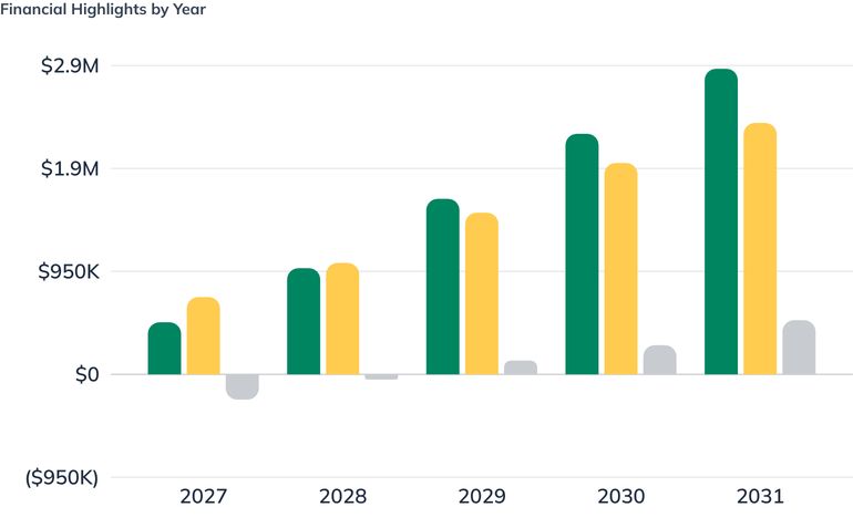
Need real financials? We recommend using LivePlan as the easiest way to create financials for your own business plan.Create your own business plan

Funding
We are raising $775,000 at launch: a $600,000 SBA 7(a) term loan at 9.5 percent over ten years, alongside $175,000 of founder equity — a 22.6 percent injection, well above the roughly 10 percent SBA lenders typically require. Approximately $276,000 buys the initial fleet, vehicle, build shop, processing lab, and leasehold improvements; the remaining $499,000 is working capital sized to carry two loss years, a winter cash trough, the second survey aircraft in late 2028, and a receivables balance that reaches $120,173 by 2031.
A $78,000 equipment loan in March 2028 funds a third aircraft and a second vehicle, and is the last borrowing in the plan. Everything from 2029 forward is funded from operating cash flow, bringing total capital raised to $853,000. We are not raising outside equity: this is a regional services business with a finite addressable market, it can reach $2.8 million in revenue on debt and retained earnings, and outside investment would push us toward growth this market cannot honestly support.
Opportunity
Problem Worth Solving
Virginia's farmers and landowners are being asked to prove more about their land than they have ever been able to measure.
The Chesapeake Bay cleanup is the clearest example. Between 2010 and 2021, Virginia agriculture cut nitrogen loading by roughly 982,000 pounds — real progress — but by the Chesapeake Bay Foundation's accounting some 6.2 million pounds still stand between the Commonwealth and its committed agricultural reduction target. The state's answer has been money: the Virginia Agricultural Cost-Share Program was funded at $223 million for FY2026, its fourth consecutive annual increase, with individual producers eligible for up to $300,000 across sixty-plus practice types. Virginia's Resource Management Plan program goes further and offers something farmers actually want — a producer who implements an approved RMP is deemed to be in full compliance with the Chesapeake Bay TMDL and state nutrient and sediment water quality standards.
That safe harbor has a catch. An RMP requires a nutrient management plan, documented stream buffers, a soil conservation plan holding erosion at tolerable rates, and cover crop practices — and every one of those components has to be mapped, verified, and re-verified. Today most of that documentation is assembled from windshield surveys, hand-drawn field boundaries, tax parcel maps, and NRCS soil survey polygons that were digitized decades ago. Farmers are signing compliance documents describing acreage they have never precisely measured, and cost-share applications get delayed or reduced because the supporting maps do not hold up.
The scouting problem is the same problem in a different season. Virginia's row-crop acreage runs roughly 1.2 million acres of soybeans, corn, wheat, cotton, and peanuts, most of it on farms averaging 187 acres and increasingly managed by operators past sixty who are covering more ground with fewer people. Walking fields is how crop stress has always been found. It does not scale, it happens after the damage is visible, and in a wet Mid-Atlantic summer it often does not happen at all. Free and low-cost satellite imagery has filled part of that gap, but at 3 to 10 meters per pixel it answers "is something wrong somewhere in this field" and nothing more precise — and in the humid coastal plain, cloud cover routinely blanks out the weekly satellite pass during the exact weeks that matter.
Landowners with timber face the starkest version of the measurement gap. Virginia is 62 percent forested — roughly 16 million acres — and 59 percent of that is held by individual and family owners rather than industry. A traditional timber cruise is priced for an industrial tract. The family that inherited 140 acres in Sussex County has no affordable way to learn what is standing on it, so they sell on the buyer's estimate, defer harvest decisions for years, or take the first offer that arrives.
Underneath all of it sits a supply chain problem that most operators have not priced in. In December 2025 the FCC added all foreign-produced unmanned aircraft systems and their critical components — flight controllers, navigation systems, sensors, cameras, batteries, motors — to its Covered List. New equipment authorizations for that hardware stopped. The American Security Drone Act already bars federal funds from being used to buy or operate covered foreign aircraft. Most of the drone service providers working Virginia farmland today fly Chinese-built aircraft, which means the customers with the strongest reason to hire a drone — the ones participating in federally funded conservation programs — are increasingly the customers those operators cannot legally serve.
So the gap is not "farmers need drones." Drones are everywhere. The gap is that the people who need defensible, high-resolution, legally usable measurements of their land cannot get them from a provider whose aircraft, data chain, and documentation will survive a compliance review.
Our Solution
SkySpecs designs and assembles its own survey aircraft in Richmond and flies them as a service. We do not sell drones. We sell measured, documented, decision-ready information about land — collected on aircraft we built, processed in our own shop, and delivered with a provenance record that stands up to a federal cost-share audit.
What we fly
Our fleet is built around two in-house airframes on a common Pixhawk-class open flight stack, assembled from a bill of materials we control and document to the component level:
- SS-M (multispectral): a 6.4 kg quadrotor carrying a Sentera 6X multispectral sensor with incident light sensor and calibrated reflectance panel, flying 180 to 240 acres per battery cycle at 2.5 cm ground sample distance.
- SS-L (LiDAR/photogrammetry): a heavier-lift airframe carrying either a survey-grade RGB payload for photogrammetry or a mid-tier LiDAR unit for canopy penetration and bare-earth modeling under leaf-off conditions.
Building rather than buying is a deliberate economic and regulatory choice, not a hobbyist preference. A comparable NDAA-compliant commercial platform runs $23,000 to $29,000 before a sensor, and roughly $43,000 with one. We assemble an equivalent-capability aircraft for materially less, we can swap payloads without waiting on a manufacturer's release schedule, and — critically — we hold country-of-origin and cost documentation for every component, which is what actually substantiates a domestic-content claim. "Assembled in Richmond" is a marketing line. A component-level bill of materials is evidence.
What we sell
Crop Intelligence. Season-long multispectral monitoring for row-crop operations: five to eight flights per field across the season, delivered as NDVI and red-edge stress maps, stand counts, gap and skip detection, and variable-rate prescription files written directly to the grower's controller format. Priced at $9 per acre per season with a $1,800 minimum per operation; single-flight diagnostic work is $6 per acre with a $750 job minimum. Prescription-file delivery adds $4 per acre. We position this against documented input savings of $8 to $15 per acre on nitrogen and fungicide — the program is designed to pay for itself in-season or we have not earned the renewal.
Compliance Documentation. Imagery-backed mapping packages built specifically for Virginia Resource Management Plans, nutrient management plans, and Agricultural Cost-Share applications: verified field boundaries and acreage, riparian and stream buffer measurement, cover crop verification, and drainage micro-topography, delivered as a georeferenced package a district conservationist or nutrient management planner can drop straight into a submission. Priced at $2,400 per plan plus $3 per acre. Annual re-verification renews at a reduced rate.
Land & Timber. Timber inventory and land mapping for family forest owners, land managers, and rural real estate: LiDAR-derived canopy height models, stem density, volume estimation, and bare-earth terrain at $28 per acre with a $3,000 minimum. Engineering-grade topographic and boundary work — site survey, volumetrics, wetlands delineation support — at $185 per acre with a $1,800 minimum. This is the season-independent half of the business and it carries the highest revenue per acre by a wide margin.
Why this holds together
The three lines share one aircraft fleet, one processing pipeline, and one customer. The Dinwiddie County operator who buys crop monitoring in June is the same person filing a cost-share application in October and the same person who owns 200 acres of loblolly he has never had inventoried. Ag work fills the growing season and builds the relationship; compliance work is anchored to program deadlines and recurs annually; timber and survey work fills the leaf-off winter months when crop imagery has nothing to say. The seasonality that kills single-line drone operators is what makes the combination work.
Satellite imagery is not our competitor — it is our top of funnel. We ingest free Sentinel-2 and low-cost Planet coverage across our clients' full acreage, use it to triage where something is changing, and dispatch aircraft to the anomalies at 100 to 200 times the resolution. A grower gets broad-acre awareness at satellite economics and centimeter measurement exactly where it earns its cost.
Target Market
The market we are actually in
The global agriculture drone market was roughly $3.4 to $4.4 billion in 2025 depending on how the category is scoped, growing at 16 to 19 percent annually. The more relevant figure for us is the US agriculture drone market — $614.7 million in 2025, forecast to reach $1.76 billion by 2030, a 23.5 percent compound annual growth rate. Within that market, services is the fastest-growing component at roughly 28 percent annually, outpacing hardware. The broader global drone services market across all verticals reached $29.9 billion in 2025, with North America accounting for about 42 percent of revenue.
Those are the headline numbers, and we treat them carefully. National market size does not put a job on our calendar. What matters is the acreage inside a day's drive of Richmond and what a landowner there will actually pay.
Our service territory
We operate a 60-mile primary radius from Richmond, covering the Piedmont and inner coastal plain. Six core counties account for roughly 86,800 acres of soybeans: Sussex (20,200), Caroline (19,800), Dinwiddie (17,100), Surry (15,300), Prince George (9,000), and New Kent (5,400). Corn and winter wheat rotate on much of the same ground, so total row-crop acreage in the core radius is on the order of 140,000 acres. A secondary tier — Southampton (18,900) and Isle of Wight (15,900) — adds roughly 35,000 soybean acres within a two-hour drive. Several nearby counties, including Essex, King William, King and Queen, Hanover, and Charles City, are suppressed in published county estimates but carry meaningful row-crop production and are not counted in either figure.
Statewide, Virginia has 38,600 farms across 7.2 million acres, averaging 187 acres, 95 percent family-owned, with an average operator age of 59.2. Total agricultural cash receipts run about $5.5 billion, and agriculture and forestry together contribute over $105 billion in annual economic impact and support more than 490,000 jobs.
The three segments we sell to
Segment 1 — Row-crop operations above 400 acres. The 187-acre statewide average is a real constraint, and we are explicit about it: at $9 per acre, a 187-acre farm is a $1,683 engagement, which is at the edge of viability once travel, flight time, processing, and reporting are loaded. Our minimum job sizes exist for that reason. Our economic buyer is the upper tail — operations farming 400 acres and up, often across multiple leased parcels — plus the aggregators who control many farms at once: ag retailers, cooperatives, and independent crop consultants who can put us across ten operations with one relationship. We estimate roughly 300 to 400 operations in our primary radius clear the 400-acre threshold.
Segment 2 — Conservation program participants. Any Virginia producer pursuing a Resource Management Plan, a nutrient management plan, or Agricultural Cost-Share funding. Eligibility for cost-share starts at five acres and $1,000 in annual income, and reimbursement runs from 50 percent up to full implementation cost, with farmer demand routinely exceeding available funding. This segment is not defined by acreage — it is defined by a filing deadline, which makes it the most predictable and most recurring demand in the plan. It also self-selects for our aircraft: participants touching federal dollars have a procurement reason to avoid providers flying covered foreign hardware.
Segment 3 — Forest and rural land owners. Virginia is 62 percent forested across roughly 16 million acres, more than 80 percent privately held, with 59 percent in individual and family hands and only 2 percent held by forest industry. Forestry contributes over $21 billion annually and supports more than 108,000 jobs. The addressable customer here is the 50-to-500-acre non-industrial private forest owner for whom a conventional cruise is uneconomic, plus consulting foresters, land trusts, rural real estate brokerages, and estate and trust administrators who need defensible valuation. This segment is season-independent and flies best in leaf-off conditions from November through March.
Buying behavior
Ag customers buy in person, on referral, and in winter. Purchase decisions for the coming season are effectively made between December and February at co-op meetings, Extension field days, and the Virginia Ag Expo — not from a web form in June. Compliance customers buy on a program calendar set by the Department of Conservation and Recreation and their local Soil and Water Conservation District. Timber and land customers arrive through consulting foresters, attorneys, and brokers rather than direct search. All three are relationship sales in a market where the same twenty people show up at every meeting, which is slow to enter and durable once entered.
Competition
Our competition falls into four categories, and only one of them is another drone operator.
Local drone service providers
Virginia Ag Drones (King and Queen County, roughly 40 miles east of Richmond) is our closest direct competitor and sits inside our primary territory. They offer autonomous spray application, crop monitoring and mapping, NDVI work with near-infrared and red-edge sensors, and forestry and wetland management including Phragmites control. They fly the DJI Mavic 3 Multispectral and quote privately.
They are a credible operator, and the forestry lane is not uncontested. Our differentiation against them is specific rather than rhetorical: their fleet is Chinese-built. Following the December 2025 FCC Covered List action and under the American Security Drone Act, that places their aircraft on the wrong side of a procurement line for any customer using federal funds — which describes a large share of the conservation and cost-share work that is the most reliable demand in this market. We also do not spray. Application work is a different business with different insurance, different chemical handling exposure, and different economics, and we have chosen not to enter it.
Other providers in the region — The Drone Co. RVA, RVA Aerial, Central Virginia Drone Services, Virginia Droneworks, AgriScan Aerial, VSI Aerial — are led by photography and general inspection work rather than agronomic or survey analytics. Nationally, the Ag Drone Directory lists roughly 109 operators offering agricultural mapping, nearly all with pricing on request. That opacity is an opportunity: we publish our rates.
Satellite imagery
This is the most serious substitute and we address it directly rather than pretending it away. Planet Labs delivers 3.5-meter imagery at near-daily revisit for roughly $0.85 per acre per year. Sentinel-2 delivers 10-meter imagery weekly for effectively nothing. A single drone flight at $6 to $9 per acre costs roughly ten times a full year of Planet coverage.
On the question "is something wrong somewhere in this field this week," satellite wins decisively and no sales argument changes that arithmetic. Drone imagery wins only where resolution is the binding constraint — plant-level stand counts, gap and skip detection, weed patch delineation, individual tree assessment, drainage micro-topography, and any measurement that has to survive a compliance review or a transaction. It also wins on cloud cover, which is not a small point in the humid Mid-Atlantic, where the weekly satellite pass is frequently obscured during the weeks that determine the season.
Our response is architectural: we run satellite as the monitoring layer and dispatch aircraft to the anomalies. That converts the substitute into our targeting mechanism and gives us a defensible answer to the obvious objection.
National analytics platforms
Sentera, DroneDeploy, Pix4D, Solvi, Taranis, and American Autonomy are frequently described as competitors. Almost none of them fly. They sell sensors, processing software, and analytics platforms to operators like us — Sentera's 6X sensor at $13,950 is a purchase, not a rival. Actual per-acre flying is fragmented among small regional operators, which is favorable: we compete locally on service, response time, and relationships rather than against venture-funded platform companies.
The real exposure is that our software stack is a permanent cost of goods paid to firms with no incentive to protect our margin. DroneDeploy runs $4,188 per year for flight and analysis; Pix4Dfields runs about $1,990 per year; Solvi tiers start at €1,499. We mitigate this by anchoring our core photogrammetry on Agisoft Metashape Professional at $3,499 perpetual and running self-hosted processing where it does not compromise deliverable quality, keeping subscription exposure to what genuinely earns its cost.
The incumbent alternative: doing it the old way
For crop work, the incumbent is a person walking the field — the crop consultant or the operator's own time. For land and timber, it is a traditional cruise or a licensed ground survey. Drone survey typically runs 50 to 75 percent below ground-based survey on sites over five acres; a conventional 20-acre topographic survey runs $15,000 to $30,000 against $3,000 to $6,000 flown. For compliance mapping, the incumbent is a tax parcel map and a hand-drawn boundary, which is free and increasingly insufficient.
Current per-acre crop consulting rates in Virginia are not publicly published, and the most-cited national figures are two decades old. Rather than cite stale data, we are collecting current quotes directly from Virginia consultants and Extension enterprise budgets during our first two quarters and will price against what we find.
Where we lose
We will lose broad-acre monitoring on price to satellite. We will lose large industrial timber cruises to established consulting forestry firms with decades of client history. We will lose spray application work entirely, and some prospects will want a single vendor for imaging and application. We will lose price-shopped one-off jobs to hobbyist operators charging $300 for an afternoon. We do not intend to compete for any of those.
Execution
Marketing Plan
This is a relationship market of a few thousand people who mostly already know each other. Our marketing is built around being visibly present in the rooms where those people make decisions, and around publishing enough substance that a skeptical agronomist or consulting forester concludes we know what we are talking about before we ever meet.
Positioning
American-built aircraft. Audit-ready data. Flown by people who farm here.
Three claims, each independently verifiable, in the order our customers care about them. Provenance answers the procurement question. Audit-ready answers the compliance question. Local answers the trust question, which in this market is the one that actually closes.
Channels, in priority order
1. Trade presence and grower meetings (primary). Purchase decisions for the coming season are made between December and February, not in June. We commit to a standing presence at the Virginia Ag Expo, the Virginia Grain Producers and Virginia Soybean Association annual meetings, county Extension field days, Virginia Cooperative Extension's Agriculture and Natural Resources programming, the Virginia Forestry Summit, and Virginia Forest Landowner Education Program short courses. We budget for exhibit space at four to six events annually and speaking slots wherever we can earn them. A twenty-minute talk on reading a stress map in front of forty growers outperforms any amount of digital spend in this segment.
2. Referral partnerships with the people who already advise our customers. Consulting foresters, independent crop consultants, ag retailers and cooperatives, Soil and Water Conservation District staff, certified nutrient management planners, farm credit lenders, rural real estate brokerages, and agricultural attorneys. These people are asked "who should I call about this" several times a month. We run a formal referral program with a documented fee for closed compliance and timber engagements, and we make our partners look good by delivering packages their clients can actually use. This is the single highest-leverage channel available to us and it is where our founders' existing network lives.
3. Demonstration flights. The most effective sales asset we have is a map of the prospect's own field. We fly one qualified field free per prospect operation, process it fully, and walk the results with the grower in person. The conversion argument is not abstract when a farmer is looking at a nitrogen deficiency in his own back forty that he had not yet seen from the road.
4. Content and search. A working library rather than a blog: how a Resource Management Plan is documented and what mapping it requires, what a cost-share application gets rejected for, what a canopy height model tells a family forest owner about standing volume, what NDVI does and does not detect. We target long-tail search around Virginia-specific compliance and program terms, where competition is thin and intent is high. Published, transparent pricing is itself a marketing position in a market where 109 of our national peers say "price on request."
5. Local and trade press. Virginia Farm Bureau publications, Virginia Forests magazine, Lancaster Farming, Richmond BizSense, and the trade press covering the domestic drone manufacturing shift. A Richmond company assembling NDAA-compliant aircraft is a story those outlets want, and it reaches both customers and future hires.
6. Government and institutional relationships. Virginia Department of Conservation and Recreation, local Soil and Water Conservation Districts, NRCS Virginia field offices, the Virginia Department of Forestry, and Virginia Tech and Virginia State University Extension. These are not advertising channels; they are credibility infrastructure. Being the operator that district staff recommend without hesitation is worth more than any campaign.
What we deliberately do not do
We do not buy broad paid search — the terms are dominated by national platforms and drone retailers, and the click intent is wrong. We do not chase real estate and wedding aerial photography, which is where most small drone operators drift and where margins collapse. We do not market on aircraft specifications; customers buy the deliverable, and the only hardware claim that matters commercially is where it was built.
Brand and materials
Field-first, not tech-first. Our photography is Virginia farmland and Virginia timber, not glossy renderings of aircraft. Sample deliverables — a real prescription map, a real RMP documentation package with the client's details removed, a real canopy height model — carry more weight than any brochure, and we lead with them. Every deliverable we hand over is a marketing asset, because in this market it gets passed around.
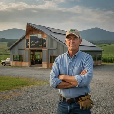
The Compliance-Focused Owner
Principal Owner
A multi-generational farm owner in the Richmond area focused on securing the future of the family legacy. They are motivated by maximizing state cost-share funding and ensuring the farm meets all Chesapeake Bay TMDL standards to avoid legal or financial penalties.
Priorities
- Securing maximum VACS program funding up to $300,000
- Maintaining 'Safe Harbor' status through RMP compliance
- Ensuring all technology used on the farm is NDAA/FCC compliant for federal programs
Evaluation Criteria
- Defensibility of data in a state compliance review
- Proven track record with local Soil and Water Conservation Districts
- Clear ROI on cost-share reimbursement success rates
Pain Points
- Cost-share applications being delayed due to inaccurate, hand-drawn maps
- The physical inability to scout 1,000+ acres of row crops effectively as the workforce ages
- Risk of losing state funding by using non-compliant foreign-made drone hardware
Common Objections
- Skeptical that drone data is significantly better than free satellite imagery
- Concerned about the high upfront cost of specialized aerial surveys
“I cannot afford to have a $200,000 cost-share application rejected because our field boundaries were 'close enough' on a tax map.”

The Efficiency Optimizer
Farm Operations Manager
Responsible for the day-to-day execution of planting, spraying, and harvesting across multiple counties. They are the primary advocate for any technology that can find crop stress before it is visible to the naked eye and save man-hours.
Priorities
- Identifying nitrogen deficiencies and pest pressure in real-time
- Optimizing labor by directing scouts only to 'hot zones' identified by drones
- Documenting cover crop emergence for RMP verification without walking every acre
Evaluation Criteria
- Speed of data turnaround from flight to actionable map
- Ability to identify specific stress types (water vs. nutrient vs. pest)
- Durability and legality of the drone fleet for use near federal conservation land
Pain Points
- Managing more acreage with fewer reliable farmhands
- Missing the window for corrective spraying because crop stress wasn't visible from the road
- The 'windshield survey' method failing to catch issues in the center of large 100-acre blocks
Common Objections
- Concerned that the data will be too complex to use for daily spraying decisions
- Worried that drone flights will interfere with tight planting and harvest schedules
“I don't need a pretty picture; I need to know exactly which 10 acres of corn are yellowing before the whole field goes south.”
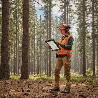
The Precision Advocate
Consulting Forester
A technical expert who advises private landowners on timber value and land health. They need high-resolution data to provide accurate cruises and management plans that justify their professional fees and protect their clients' interests.
Priorities
- Providing accurate timber stand counts for family-owned tracts
- Reducing the time spent on manual field traverses in dense Sussex County brush
- Integrating high-resolution imagery into GIS-based management plans
Evaluation Criteria
- Resolution quality (centimeters per pixel vs. meters per pixel)
- Ease of importing drone data into standard forestry GIS software
- Reliability of the service provider to fly during critical seasonal windows
Pain Points
- Relying on buyer-side estimates for timber value due to lack of affordable cruising tools
- Cloud cover in the humid coastal plain ruining satellite-based monitoring windows
- Difficulty explaining complex land health issues to owners using low-resolution maps
Common Objections
- Worried that drone services will be priced for industrial timber giants, not family tracts
- Concerned about the learning curve for interpreting multi-spectral imaging
“My clients are selling their timber based on the buyer's guess because they don't have a map that proves what's actually standing on their 140 acres.”
Sales Plan
How we sell
Our founders sell for the first two years. This is a consultative, in-person, agronomically literate sale, and it cannot be handed to a rep who has never stood in a soybean field in August. We hire a dedicated account executive in 2029, once the offer is proven and the sales motion is documented enough to teach.
The cycle runs long and seasonal. A row-crop operation typically takes one full season from first contact to a signed multi-field program: introduction at a winter meeting, a free demonstration flight in the spring, a small paid engagement mid-season, and a full-acreage program the following year. Compliance work moves faster because it is deadline-driven — a producer facing a cost-share application window will engage within weeks. Timber engagements are transactional and close in two to six weeks, usually on a consulting forester's recommendation.
The three motions
Crop Intelligence — land and expand. We do not attempt to sell a whole operation on the first pass. We fly one field free, deliver the full analysis in person, then sell a single-field paid engagement at $6 per acre. The following season we sell the season-long program at $9 per acre across the operation. The renewal argument is the input savings we documented on the prior year's own ground, which is the only argument that survives a farmer's cost scrutiny.
Compliance Documentation — sell through the planner, not the farmer. The buying trigger is a filing deadline, and the person who controls it is usually a certified nutrient management planner, a district conservationist, or a consulting agronomist rather than the landowner. We build relationships with those planners, become the mapping provider they specify by default, and let the engagement arrive pre-qualified. Annual re-verification converts a one-time filing into a recurring account.
Land & Timber — sell through the forester and the closing table. Consulting foresters, land trusts, estate attorneys, and rural brokerages generate this work. We price against the alternative the client already understands — a $15,000 to $30,000 ground survey, or an unknown standing volume they are about to sell on the buyer's estimate. Because it is season-independent and flies best leaf-off, this pipeline is worked hardest in late summer for a November-through-March delivery calendar.
Pipeline and process
We run on HubSpot's free-to-starter CRM tier with pipeline stages tied to the season rather than to generic sales stages: Identified, Winter Meeting Contact, Demo Flight Scheduled, Demo Delivered, Paid Pilot, Program Signed, Renewed. Every deliverable is logged against the account so that the renewal conversation starts with what we actually found on that customer's ground last year.
Proposals are fixed-scope and fixed-fee against published rates. We do not negotiate per-acre pricing, and we say so early. What we will flex is scope, flight count, and payment timing — never rate — because a market this small will know within one season if we discount, and published pricing is worthless the moment it becomes a starting point.
Terms
Crop Intelligence programs are contracted for the full season with 40 percent invoiced at signing and the balance in two installments at mid-season and season close, which puts cash in before the flying is done. Compliance packages invoice 50 percent at engagement and 50 percent on delivery. Land and timber work invoices 50 percent at scheduling and 50 percent on delivery of final data. Standard terms are net 30, and we expect real collection periods with agricultural customers — whose own cash arrives at harvest — to run closer to 45 days. The heavy front-loading of our invoicing schedule is deliberate for exactly that reason.
Targets and quality control
Our first-year objective is 18 to 25 recurring accounts — crop programs and compliance relationships that we expect to renew — alongside the transactional timber and survey engagements that make up the rest of the book. We track those two categories separately on purpose: a 140-acre timber inventory is a job, not an account, and counting jobs as accounts would flatter a renewal rate that has to mean something. A small book of well-served customers in a market this interconnected compounds faster than a large book of dissatisfied ones.
We track close rate from demonstration flight, program renewal rate, and referral-sourced share of new business as our three leading indicators. Any engagement that we cannot deliver at published turnaround gets declined rather than accepted and delivered late; in a referral market, one blown deadline in August costs more than the job was worth.
Locations & Facilities
Headquarters
SkySpecs operates from a single leased facility of approximately 3,200 square feet in a light-industrial flex park in eastern Henrico County, off the Airport Drive corridor near Richmond International. The space combines warehouse and office under one roof at flex-park rates rather than office rates, which is the entire reason for the location choice — we need a shop floor and we do not need a storefront.
The building divides into four functional areas:
- Assembly and build shop (roughly 1,200 sq ft): ESD-safe workbenches for airframe and avionics assembly, component inventory with bin-level country-of-origin labeling, a small machining and 3D printing station for mounts and payload adapters, and a LiPo-safe charging and storage room with fire suppression and dedicated ventilation. Battery storage is a genuine facility requirement, not an afterthought, and it drives our fire code and insurance conversations.
- Maintenance and pre-flight bay (roughly 500 sq ft): post-flight inspection, sensor calibration, propulsion testing, and airframe repair, with a tethered test stand for motor and ESC verification.
- Geospatial processing lab (roughly 700 sq ft): two high-specification photogrammetry and point-cloud workstations at launch, with a third added in 2029 as job volume grows; calibrated color-managed displays for imagery review; and network-attached storage running a RAID array with offsite replication. Processing runs on-premises rather than in the cloud for large LiDAR datasets, where transfer time and egress cost exceed the value of remote compute.
- Office and client space (roughly 800 sq ft): four workstations, a small conference area where we walk growers and landowners through their own data, and administrative space.
We are targeting an initial three-year lease with a renewal option on the same footprint, which carries the plan through Year 5 for office and processing without relocation.
Why Richmond
Richmond sits at the center of our addressable geography rather than at its edge. From Henrico County, our primary 60-mile service radius reaches south into Dinwiddie, Sussex, and Prince George, east into Charles City, New Kent, and Surry, and north into Caroline and Hanover — roughly 87,000 acres of soybeans and on the order of 140,000 row-crop acres counting corn and wheat in rotation, plus substantial private forest — all as day trips with no overnight cost. Our secondary tier, Southampton and Isle of Wight, is reachable within two hours.
Richmond also puts us in the same city as the Virginia Department of Conservation and Recreation, the Virginia Department of Forestry, the Virginia Department of Agriculture and Consumer Services, and the state offices whose programs generate our compliance demand. Those relationships are conducted in person, and proximity to them is worth more than a cheaper lease forty minutes out. Labor availability is a further factor: Richmond metro wages run roughly at national par to five percent below for technical and managerial roles, and the region supplies geospatial, engineering, and technician talent through Virginia Commonwealth University, Virginia State University, John Tyler and Reynolds community colleges, and the Richmond-area defense and aviation supply base.
Field operations
Field work is run out of a crew truck at launch, joined by a cargo van in spring 2028 and a third vehicle in 2031 — each fitted out as a mobile flight operations base with a generator, battery charging capacity, a ground control station, ruggedized field storage, and spare airframe components. Crews launch from the client's property; there is no satellite office and none is planned. Weather-driven rescheduling is managed centrally against a rolling flight calendar, and our service radius is drawn specifically so that no scheduled mission requires an overnight stay.
Growth and constraints
The build shop is the constraint that will bind first. If aircraft assembly grows beyond roughly eight to ten airframes per year, or if we begin building for third parties, we will need additional bench space and a second LiPo storage room. We would address that by taking adjacent flex space in the same park rather than relocating, and we have selected a park with contiguous availability for that reason — the step up in facility cost from 2030 in the financial plan reflects that option being exercised.
Data storage is the second constraint. LiDAR and high-resolution multispectral archives grow fast and clients expect retrievability for years, since the compliance and timber value of our work is partly historical comparison. We plan for storage capacity expansion annually rather than treating it as a one-time purchase.
Technology
Our technology stack spans four layers: the aircraft we build, the sensors we fly, the pipeline that turns imagery into deliverables, and the systems that run the business. We build where building creates cost or compliance advantage and we buy everywhere else.
Flight platform
Both airframes run an open, auditable flight stack — Pixhawk-class flight controllers on ArduPilot firmware, with mission planning in QGroundControl and ArduPilot Mission Planner. The choice is deliberate. Open firmware means we can inspect and modify the code path that touches our customers' data, we are not dependent on a manufacturer's release cadence or geofencing decisions, and we can document the software supply chain the same way we document the hardware one. Our CTO maintains our firmware fork and our payload integration layer.
Because a self-assembled aircraft is not a Standard Remote ID aircraft off the shelf, Remote ID is engineered in rather than bolted on. Every airframe carries compliant broadcast capability by design, and Remote ID hardware appears in our per-airframe bill of materials as a required line item, not an accessory.
RTK correction comes from the Virginia Department of Transportation's VRS network with a base station fallback, giving us centimeter-level positional accuracy without a per-site survey control setup on most jobs.
Sensors
- Multispectral: Sentera 6X system with incident light sensor, GPS module, and calibrated reflectance panel. The OEM and custom-integration configurations are priced identically to the drone-specific versions, which makes them the natural fit for a self-assembled airframe.
- RGB survey: a full-frame high-resolution camera for photogrammetry and orthomosaic production at engineering tolerances.
- LiDAR: a mid-tier commercial unit for canopy penetration, bare-earth terrain modeling, and timber volume work. This is our single most expensive payload and it is what makes the leaf-off forestry business possible.
- Thermal: a radiometric payload added in spring 2028 for irrigation, drainage, and livestock-facility work.
Data pipeline
Capture through deliverable runs on-premises:
- Photogrammetry and point cloud processing: Agisoft Metashape Professional, licensed perpetually rather than by subscription. Processing continuously, it pays back against subscription alternatives inside a year and then costs nothing further.
- Agronomic analytics and prescriptions: Pix4Dfields for vegetation indices, zone delineation, and variable-rate prescription export in the controller formats our customers actually run.
- GIS and cartography: QGIS with PostGIS as the spatial database of record. Deliverable packages are produced as georeferenced GeoTIFF, shapefile, and PDF map sets that drop directly into a nutrient management plan submission or a forester's existing workflow.
- Satellite triage layer: automated ingestion of free Sentinel-2 coverage and low-cost Planet imagery across enrolled client acreage, with change detection flagging anomalies that dispatch an aircraft. This is the mechanism that turns our most serious substitute into our targeting system.
- Machine learning: stand counting, gap and skip detection, weed patch delineation, and individual tree segmentation run on trained models against our own accumulating imagery library. We treat this as standard tooling rather than a differentiator — every serious operator in this market runs comparable models — but our Virginia-specific training data on Mid-Atlantic crops and Southern pine improves with every season we fly.
Data custody
Client imagery and derived products are stored on RAID network-attached storage with encrypted offsite replication, retained for a minimum of seven years, and never used for a purpose the client has not agreed to. Because a meaningful share of our work supports regulatory filings and land transactions, we maintain chain-of-custody metadata — flight logs, sensor calibration records, processing parameters, and operator identity — attached to every deliverable. That record is the difference between a picture and evidence, and it is a core part of what customers are buying from us.
Clients own their data. We do not resell it, and we do not aggregate it into a product sold back to the industry. In a market built on personal trust, the value of being the operator who does not monetize the customer's field is higher than the value of the data.
Business systems
HubSpot for CRM, QuickBooks Online for accounting, Rippling for payroll and benefits administration, Notion for internal documentation and standard operating procedures, and a purpose-built flight operations log for FAA-required records, maintenance intervals, battery cycle counts, and per-airframe component history. That last system is not off-the-shelf software; it is the operational backbone of both our airworthiness practice and our domestic-content documentation, and we built it ourselves.
Equipment & Tools
The build-versus-buy case
The clearest way to understand our equipment strategy is to price the alternative. A comparable NDAA-compliant commercial airframe runs $23,000 to $29,000 — a Freefly Astro Max lists at $28,995, an Inspired Flight IF800 Tomcat starts around $23,000 — before any sensor. Add a Sentera 6X at $13,950 and a compliant multispectral aircraft costs roughly $43,000 off the shelf. Compliant hardware carries a documented premium of three to ten times comparable Chinese consumer platforms, because the vetted supply chain is what is actually being sold.
We assemble the SS-M multispectral airframe for a bill of materials in the range of $13,500 to $14,500 plus roughly 24 hours of in-house technician time — carbon airframe, US-sourced flight controller, motors, ESCs, propulsion and power distribution, RTK GNSS module, telemetry and Remote ID broadcast hardware, batteries, and ground control equipment. With the Sentera 6X mounted, a complete SS-M lands well under the $43,000 purchased equivalent. The SS-L heavy-lift airframe runs higher on the airframe side and carries either a survey RGB payload or a mid-tier commercial LiDAR unit at $30,000 to $50,000, which is the single largest equipment line in the plan and the one that opens the timber and engineering-survey business.
The saving per airframe is real, but it is the second-most-important reason we build. The first is that we hold component-level cost and country-of-origin records for every part we install, which is the only thing that actually substantiates a domestic-content claim under the current FCC exemption framework. An operator who buys a finished aircraft inherits whatever documentation the manufacturer chooses to provide.
Fleet plan
- Launch (2027): two SS-M multispectral aircraft and one SS-L survey aircraft with both RGB and LiDAR payloads, plus one spare airframe kit held in inventory. Two aircraft of the same type is a minimum, not a luxury — an aircraft down for repair during a three-week timing window is a season's worth of relationships lost.
- Year 2 (2028): a third SS-M as crop program acreage grows, with a radiometric thermal payload, in March; and a second SS-L with LiDAR payload in November, ahead of the 2028–29 leaf-off window. The fleet stands at five aircraft entering 2029.
- Year 3 (2029): processing lab expansion rather than fleet expansion. Five aircraft carry the acreage; the constraint moves to turnaround time.
- Year 4 (2030): the first four-year refresh cycle — airframe rebuild and sensor upgrade across the launch fleet, budgeted rather than assumed away, because a payload bought in 2027 will not be competitive in 2031.
- Year 5 (2031): a sixth aircraft and a third field vehicle in March, funded from operating cash flow, matched to the third field crew.
We plan a four-year service life per airframe with continuous component-level replacement throughout.
Shop and field equipment
Build shop: ESD-safe benches, soldering and rework stations, a bench power supply and load tester, a motor and ESC test stand, precision balancing equipment, a small CNC and FDM 3D printer for mounts and payload adapters, calibrated torque tooling, and bin-level component inventory with country-of-origin labeling. LiPo-safe charging and storage with fire suppression and dedicated ventilation is a code and insurance requirement, not an option.
Processing lab: two high-specification workstations at launch, built for photogrammetry and point-cloud work — high core-count CPUs, 128 GB of RAM, professional GPUs, and fast local NVMe scratch — plus color-calibrated displays and RAID network-attached storage with encrypted offsite replication. A third workstation and additional storage are added in 2029. Point clouds do not process on laptops, and processing time is a direct constraint on how many jobs we can turn in a week.
Field: vehicles fitted as mobile flight operations bases — a crew truck at launch, a cargo van from April 2028, and a third vehicle in March 2031 — each with generator, multi-bay battery charging, ruggedized transit cases, ground control station and tablets, portable RTK base station, weather and wind measurement instruments, high-visibility crew equipment, and spare propellers, batteries, and line-replaceable components. Ground control points and survey targets for engineering-tolerance work.
Software licenses are covered in the Technology section; the notable capital item there is Agisoft Metashape Professional at $3,499 perpetual per seat, bought outright rather than subscribed.
Insurance
Our coverage runs above the entry-level tier that most published drone insurance benchmarks assume. A $1 million liability policy alone runs $450 to $600 annually, but hull coverage on a self-assembled, non-type-certificated aircraft carrying a $14,000 sensor is priced differently and placed with fewer carriers — we budget in the $1,500 to $2,500-plus range per aircraft-and-payload combination. Survey and mapping work for engineering and land-transaction clients additionally requires professional liability and errors-and-omissions coverage, which no general aviation liability policy includes. We place all of it through an aviation-specialist broker rather than a general commercial agent, and we confirmed both the hull placement and the E&O requirement before finalizing our cost model rather than after.
Regulatory Compliance & Certifications
Regulatory standing is not overhead for this business — it is the product. Customers filing conservation applications, documenting compliance safe harbors, or supporting land transactions are buying evidence, and evidence is only as good as the operator's authority to have collected it. This section states where we stand and what we are obligated to maintain.
FAA operating authority
We operate under 14 CFR Part 107. Both founders and every field pilot hold a Remote Pilot Certificate with a small UAS rating, maintained through the required recurrent training. We hold Part 107 waivers where our work requires them and we do not fly outside our authorizations — no exceptions, including for a client with a deadline.
Remote ID compliance has been mandatory since March 16, 2024, with no grace period and civil penalties reaching $27,500 per violation plus certificate action. Because our aircraft are self-assembled, they are not Standard Remote ID aircraft by default. We engineer compliant broadcast capability into every airframe and carry it as a required line in the build specification.
Beyond visual line of sight operations today require case-by-case Part 107 waivers. The FAA's proposed Part 108 BVLOS rule was published as an NPRM on August 7, 2025; its comment period closed, was reopened in January 2026, and closed again in February 2026, and no final rule has been issued. No operator can claim Part 108 authority today. We plan and forecast entirely on visual-line-of-sight operations. We treat Part 108 as upside in a scenario, and we note the risk honestly: when BVLOS is normalized, acres-per-hour rises industry-wide and per-acre pricing compresses. It is a margin risk as much as an opportunity.
We also maintain a documented flight operations manual, per-flight and per-airframe logs, maintenance intervals, battery cycle tracking, and incident reporting procedures. These exist because they are good practice and because they are the records a customer's auditor eventually asks for.
Supply chain and domestic content
On December 22, 2025, the FCC added all foreign-produced unmanned aircraft systems and their critical components to the Covered List — a first-of-its-kind action defining critical components expansively to include flight controllers, navigation systems, communications and data transmission equipment, ground control stations, sensors, cameras, batteries, battery management systems, and motors, along with associated software. New equipment authorizations for that hardware are prohibited. Previously authorized models remain legal to sell and use. Separately, the American Security Drone Act bars federal agencies from operating covered foreign aircraft and prohibits contractors and grant recipients from using federal funds to purchase or operate them.
In January 2026 the FCC issued two exemption pathways: Blue UAS Cleared List platforms and components, and a Buy American domestic end product standard requiring domestic component cost exceeding 65 percent of total value for calendar years 2024 through 2028, rising to 75 percent from 2029, together with substantial transformation in the United States under CBP guidance. Qualifying requires submitting corporate structure documentation, manufacturing specifics, complete supply chain records with country of origin for every component, and an onshoring plan, approved by the Department of War or DHS.
The assumption this plan makes, stated plainly
Both exemption pathways carry a stated expiry of January 1, 2027 — the first month of this forecast. DJI's petition for reconsideration and related litigation remain unresolved, and the rulemaking is actively evolving.
This plan assumes the pathways are extended or superseded by a successor framework on comparable terms, with the domestic content thresholds running at 65 percent through 2028 and 75 percent from 2029 as currently written. That is the assumption every domestic-content statement elsewhere in this plan rests on, and we would rather name it than bury it.
If instead the pathways lapse outright on January 1, 2027, the practical effect is not that we lose our position — it is that the market's compliant-hardware supply tightens further and the premium on domestically built aircraft rises, which favors an operator who builds its own. What we would lose is the specific safe harbor language we can put in front of a procurement officer, and we would fall back to Green UAS certification and our own documented bill of materials as the evidentiary basis. We are pursuing that certification for exactly this reason, and we monitor the docket quarterly.
Our obligations, specifically
- Assembly in Richmond is not by itself compliance. Flight controllers, motors, batteries, and sensors are commonly sourced from China even by US assemblers. Meeting the threshold requires deliberate sourcing decisions on every one of those lines, and we make them at design time rather than at purchase time.
- We maintain a component-level bill of materials with country of origin and cost from the first airframe. Retrofitting that documentation later is far harder than maintaining it from the start, and it is the evidentiary basis for every compliance claim we make to a customer.
- We are pursuing Green UAS certification through AUVSI. Since 2025 the Department of War has recognized Green UAS as a pathway toward Blue UAS status via the Recognized Assessor program. For a company whose differentiation is provenance, third-party certification converts a marketing claim into a procurement qualification.
- We over-comply rather than sit at the threshold. We target domestic content comfortably above the required percentage, qualify a second source for every critical component, and treat the sourcing review as a standing quarterly exercise owned by our CTO — with a full re-qualification against the 75 percent standard completed in late 2028, ahead of its 2029 effective date.
- We are precise in our language. "NDAA-compliant" is descriptive, not a certification — no agency issues such a badge, and the term traces to Section 848 of the FY2020 NDAA. Overclaiming here carries real procurement risk, and we do not do it.
State, local, and professional standing
We are organized as a Virginia corporation, registered with the State Corporation Commission, holding a Henrico County business license and Virginia sales tax registration, with workers' compensation coverage as required for a Virginia employer.
Aviation liability, hull coverage on self-assembled airframes, and professional liability and errors-and-omissions coverage are placed through an aviation-specialist broker, as described in Equipment & Tools. E&O is not optional for us: when a client relies on our acreage measurement in a regulatory filing or our volume estimate in a timber sale, our exposure is professional, not just aviation.
We are not a licensed land surveying firm. Under Virginia law, boundary determination and certain plats require a licensed professional land surveyor. We are explicit with clients about this line: we deliver topographic, volumetric, and mapping products, and where a survey requires certification we partner with a licensed Virginia surveyor who reviews and stamps the work. Blurring that line would be both illegal and, in a referral market, commercially fatal.
For agronomic recommendations, our prescription outputs are delivered as decision support to the grower and their agronomist. Where a nutrient management plan requires a certified planner's signature, the certified planner signs it — we supply the measurement and the documentation, and we do not represent ourselves as the plan writer.
Milestones
Close SBA 7(a) financing and execute Henrico lease Fund the $600,000 SBA 7(a) facility alongside $175,000 in founder equity, sign the three-year lease on the 3,200 sq ft Henrico flex space, and place aviation liability, hull, and E&O coverage through an aviation-specialist broker. | Nathan Ordway Jan 15, 2027 |
SS-L survey aircraft with LiDAR payload operational Heavy-lift airframe accepted with both the survey RGB and LiDAR payloads before the first survey engagement in February. RTK workflow validated against known control, and the licensed Virginia surveyor review relationship in place ahead of any work requiring a stamp. | Priya Raghunathan Feb 15, 2027 |
First two SS-M aircraft built, flight-qualified, and in service Complete assembly and flight qualification of both multispectral airframes with Sentera 6X payloads and engineered Remote ID broadcast. Component-level bill of materials with country-of-origin and cost recorded for every part from the first airframe forward. | Priya Raghunathan Mar 1, 2027 |
Green UAS certification application submitted Submit the AUVSI Green UAS application with full supply chain documentation after the first two build cycles have produced a complete component-level bill of materials, turning our domestic-content claim from a marketing statement into a procurement qualification. | Priya Raghunathan Sept 30, 2027 |
20 recurring accounts signed in the first season Close the first full season with at least 20 recurring accounts — crop intelligence programs and compliance relationships we expect to renew — alongside the transactional timber and survey engagements counted separately. Demonstration-flight conversion tracked at one in three or better. | Nathan Ordway Oct 31, 2027 |
First full leaf-off timber season completed Deliver a complete November-through-March timber inventory season, proving the season-independent half of the business and the consulting-forester referral channel that drives it. | Senior UAS Pilot Mar 31, 2028 |
Third aircraft, thermal payload, and second field vehicle in service Fund and deploy the $78,000 equipment facility: SS-M aircraft #3 with a radiometric thermal payload ($42,000) in March and a second field operations vehicle ($36,000) in April, doubling in-season crop capacity alongside the second pilot hire. | Priya Raghunathan Apr 30, 2028 |
Domestic content re-qualified ahead of the 2029 threshold step-up Complete a full supply chain review and re-source as needed so every airframe clears the 75 percent domestic content standard that takes effect in 2029, with a qualified second source for every critical component. | Priya Raghunathan Nov 30, 2028 |
Second SS-L in service; parallel timber crews running Add the second heavy-lift survey aircraft with LiDAR payload before the 2028-29 leaf-off window opens, so two crews can run simultaneously through the January-to-March peak — lifting the ceiling on the highest revenue-per-acre line in the business. | Priya Raghunathan Nov 30, 2028 |
Cash trough passed and sustained cash-flow break-even Clear the January 2029 low point in cash and reach the point where operating cash generation covers payroll, operating expenses, and debt service without drawing further on the launch cushion. Operating income turns positive in 2028; from here each year ends higher in cash than the last, within the normal seasonal swings. | Nathan Ordway Mar 31, 2029 |
First profitable full year closed Close 2029 with positive net profit, program renewal rate above 80 percent, and referral-sourced business exceeding half of new bookings. | Nathan Ordway Dec 31, 2029 |
Fleet refresh complete and operations leadership in seat Complete the first four-year airframe and sensor refresh cycle, and seat an Operations Manager so day-to-day scheduling, safety, and crew management move off the founders. | Nathan Ordway June 30, 2030 |
Sixth aircraft and third field crew in service Fund the $95,000 fleet and vehicle expansion from operating cash flow and seat the third field crew — an additional UAS pilot and a field technician — carrying the business to its $2.8M closing-year revenue with no further borrowing required. | Operations Manager Mar 31, 2031 |
Key Metrics
We run the business on nine numbers, reviewed monthly. They are grouped by the question each one answers.
Are we flying enough?
Billable acres flown per month, by service line. Our single most important operating number, tracked separately for Crop Intelligence, Compliance Documentation, and Land & Timber because the three lines differ by more than an order of magnitude in revenue per acre. A blended acreage figure hides everything that matters.
Aircraft utilization — billable flight hours per aircraft per month. Capacity in this business is aircraft-days multiplied by usable weather, and it is seasonal by nature. We track utilization against the achievable ceiling for the month rather than against a flat target, and we watch it hardest during the leaf-off timber window, when a grounded SS-L costs the most.
Weather cancellation and reschedule rate. In the Mid-Atlantic this is the difference between a plan and a fantasy. If reschedules exceed 25 percent of booked missions in a month, our scheduling buffer is wrong, not the weather.
Are we making money on the work?
Revenue per billable flight hour. The cleanest measure of mix quality. Timber work at $28 per acre earns roughly three times the per-acre rate of crop scouting, and engineering-grade survey at $185 per acre roughly twenty times — so this number tells us immediately whether we are drifting toward cheap acres.
Gross margin by service line. Direct costs — field travel, per-job software and data credits, subcontracted licensed survey and planner review — tracked against each line separately. We expect Compliance and Land & Timber to carry Crop Intelligence, and we want to know immediately if that stops being true.
Processing turnaround time, capture to delivery. Our published commitment, and our most common failure mode. Processing capacity, not flying capacity, is what typically binds first in a growing drone services business, and turnaround slipping is the leading indicator that we need another workstation or another analyst.
Are the customers staying?
Program renewal rate. The percentage of Crop Intelligence and Compliance accounts that renew for the following season or filing year. This is the number that determines whether we are building an asset or running a treadmill, and our target is above 80 percent by Year 3.
Referral-sourced share of new business. In a market where the same few hundred people attend the same meetings, a rising referral share means the work is speaking for itself. If new business is arriving mostly from cold outreach after Year 2, the deliverables are not good enough.
Demonstration-flight conversion rate. Free demo flights are our largest sales investment. We track what share convert to a paid engagement within two seasons, and we cut back the program if it falls below one in three.
The two we watch that are not performance metrics
Documented domestic content percentage per airframe. Reviewed quarterly by our CTO against the applicable FCC threshold — 65 percent for calendar years through 2028, 75 percent from 2029. This is a compliance obligation, but we treat it as a headline metric because our market position depends on it and because a single-sourced component reclassification could put an aircraft on the wrong side of the line without warning.
Safety and incident record. Flight hours between reportable incidents, plus near-miss reports logged. We want near-misses reported generously and we say so, because an operator who hides small problems eventually has a large one, and one accident in a referral market this tight ends the company.
Company
Ownership & Structure
Legal structure
SkySpecs, Inc. is a Virginia corporation registered with the State Corporation Commission, headquartered in Henrico County, Virginia, and taxed as an S corporation. The S election passes income through to the shareholders and avoids entity-level federal income tax while preserving the corporate form, which matters here for three reasons: it supports the SBA 7(a) financing structure, it gives us a clean vehicle for equity compensation as we hire technical staff, and it presents the governance shape that institutional customers and state agencies expect from a vendor supporting regulatory filings.
We chose a corporation over an LLC deliberately. Our differentiation depends on documented compliance, third-party certification, and customer confidence in our custody of evidence. A corporate structure with a real board, real minutes, and clean capitalization is easier to diligence, and we expect to be diligenced.
Ownership
The company is founder-owned, with two shareholders at launch:
- Nathan Ordway, Co-founder and Chief Executive Officer — majority shareholder
- Priya Raghunathan, Co-founder and Chief Technology Officer — minority shareholder
Both founders contribute cash equity at formation alongside the SBA 7(a) financing described in Sources of Funds. Neither founder takes outside investment at launch, and the SBA facility is personally guaranteed by both, as is standard for a 7(a) loan of this size.
A stock option pool is reserved for employees, sized so that the geospatial, engineering, and senior pilot roles we compete hardest for can be offered equity participation. We compete for scarce technical talent against Richmond employers who pay well, and equity is part of how a company at our stage wins those hires.
Governance
The board consists of the two founders plus one independent director recruited before the end of Year 1, with agriculture-sector or regulated-services operating experience. Formal board meetings are held quarterly against a standing agenda: financial review, pipeline and renewals, safety and incident record, and the quarterly supply chain and domestic content review described in Regulatory Compliance & Certifications.
A shareholders' agreement executed at formation covers transfer restrictions, valuation methodology, buy-sell provisions on death or departure, and dispute resolution. Key person life insurance is carried on both founders, with the company as beneficiary, as required under the SBA facility and as a matter of ordinary prudence in a two-person-dependent business.
Roles and division of authority
Authority is split along the natural fault line of the business. The CEO owns commercial responsibility — sales, customer relationships, agronomic delivery, partnerships, and finance. The CTO owns technical responsibility — aircraft design and build, firmware, the data pipeline, and the compliance and supply chain documentation on which our market position rests. Hiring, capital expenditure above a defined threshold, pricing changes, and any decision touching regulatory posture require both founders' agreement.
We are clear-eyed about the concentration risk this creates in a two-person company. Our mitigation is documentation rather than optimism: standard operating procedures for build, flight, and processing are written and maintained as work is done, not retroactively, so that the business does not live only in two people's heads. Cross-training the first pilot and first analyst into build and processing respectively is an explicit Year 2 objective.
Management Team
Founders
Nathan Ordway — Co-founder and Chief Executive Officer
Nathan grew up on a row-crop operation in Dinwiddie County and holds a B.S. in Agricultural and Applied Economics from Virginia Tech. He spent seven years as a field agronomist and precision agriculture lead for a regional agricultural retailer covering the Virginia coastal plain, where he wrote variable-rate prescriptions across roughly 40,000 acres annually and worked directly with Soil and Water Conservation District staff on nutrient management planning and Agricultural Cost-Share applications. He holds a Part 107 Remote Pilot Certificate and Virginia nutrient management planner certification.
Nathan owns sales, customer relationships, agronomic delivery, partnerships, and finance. The reason he is the right person to sell this is not credentials — it is that the growers in Sussex, Dinwiddie, and Prince George counties already take his calls, and he has spent seven years watching cost-share applications get delayed for exactly the mapping deficiencies this company exists to fix.
Priya Raghunathan — Co-founder and Chief Technology Officer
Priya holds a B.S. in Electrical Engineering from Virginia Commonwealth University and spent nine years in unmanned systems engineering, most recently as a senior embedded systems engineer at a Northern Virginia unmanned aircraft manufacturer, where she led flight controller integration and payload interface work and sat through the supply chain re-sourcing exercise that followed the 2024–2025 restrictions on Chinese components. She has built and flown ArduPilot-based airframes since graduate school and holds a Part 107 certificate.
Priya owns aircraft design and build, firmware, the data pipeline, and — critically — the component-level bill of materials and country-of-origin documentation that substantiates our domestic content position. She has done that re-sourcing work before at a company where it was an emergency. Here it is designed in from the first airframe.
Hiring sequence
Our hiring is driven by where capacity binds, in this order.
Year 1
- Part-time bookkeeper (January 2027), converting to a full-time Office and Administrative Coordinator in January 2028 as invoicing volume, payroll, and compliance recordkeeping grow past what the founders should be doing.
- Senior UAS Pilot / Field Operations Lead (March 2027). A Part 107 pilot with survey or photogrammetry experience — the combination is scarce and we pay accordingly. Runs the flight calendar, leads field crews, owns the flight operations manual and safety practice, and cross-trains into build during the winter.
- Geospatial Analyst (May 2027). Photogrammetry, point cloud processing, and GIS cartography — the person who turns captured imagery into a deliverable a district conservationist or consulting forester can use. Processing capacity, not flying capacity, is what binds first in this business, and this hire is why.
Year 2
- UAS Pilot (March 2028). Doubles in-season field capacity alongside the third aircraft.
Year 3
- Account Executive (February 2029). Hired once the sales motion is proven and documented enough to teach, on a base-plus-commission structure weighted toward base to reflect a long, technical, seasonal cycle.
- Agronomy and Client Success Lead (March 2029). Owns program delivery and renewals so that customer relationships stop being single-threaded through the CEO.
- Assembly and Maintenance Technician (April 2029). Takes airframe build and maintenance off the CTO, which is the single largest constraint on her time.
Year 4
- Operations Manager (February 2030) and a second Geospatial Analyst (April 2030), as job volume and crew scheduling outgrow founder-led coordination.
Year 5
- A third field crew — an additional UAS pilot and a field technician, hired together in March 2031 — matched to the sixth aircraft and third vehicle.
Compensation philosophy
We pay to the Richmond metro market, not to a national average and not to a Virginia statewide average — the statewide figure is inflated roughly seven to eight percent by the Northern Virginia and Washington market and would systematically overstate our costs. Richmond runs approximately at national par to five percent below for technical and managerial roles and at or slightly above for sales and administrative roles.
Within that market we pay at or above the median for genuinely scarce skills — senior pilots with geospatial capability, geospatial analysts, embedded engineering — and at market median for roles where the local supply is deep, including entry and mid-level Part 107 pilots, assembly technicians, and administrative staff. Part 107 certification alone is not scarce; there are more than 220,000 certificated remote pilots nationally. The pilot who can also close a photogrammetry loop to survey tolerance is scarce, and the difference in what we pay reflects that difference honestly. Specific starting salaries by role are set out in the Expenses & Costs section.
Founders take below-market salaries in Year 1 and step toward market as the business supports it. All employees receive employer-contributed health coverage, and equity participation is available for the technical roles we compete hardest to fill.
What we are missing
We are two founders with deep agronomic and engineering capability and no experienced financial or general management leadership. Below roughly $2 million in revenue we consider that the right trade — the money is better spent on aircraft and analysts. We address it in the interim with a fractional CFO engagement, an experienced independent director, and the Operations Manager hire in February 2030, and we would rather name the gap plainly than pretend a two-person founding team covers every function.
Advisors
We recruit advisors for the two things we cannot buy: access to the specific rooms our customers occupy, and honest technical review of claims we are not qualified to check on ourselves.
Advisory board
We are seating a five-person advisory board that meets semi-annually, with individual members consulted as needed. The board is advisory rather than fiduciary; governance sits with the board of directors described in Ownership & Structure. Advisors are compensated with a modest annual retainer and, for the two most operationally involved seats, a small equity grant vesting over three years.
Agronomy and grower relationships. A senior agronomist or retired Virginia Cooperative Extension agent with standing among coastal plain and Piedmont row-crop operators. This seat validates our agronomic deliverables and opens the winter meeting circuit that our marketing depends on.
Conservation policy and program administration. A former Soil and Water Conservation District or Department of Conservation and Recreation staff member who has administered Agricultural Cost-Share and Resource Management Plan submissions. This person tells us what actually gets an application rejected, which is the difference between a mapping package that is technically impressive and one that is useful.
Consulting forestry. A Virginia registered consulting forester with an active client base among non-industrial private forest owners. Our timber inventory business lives or dies on whether foresters trust and recommend our volume estimates, and this seat is our reality check on both methodology and pricing.
Unmanned systems engineering and compliance. An engineer or program lead with direct experience in Blue UAS and Green UAS certification and defense supply chain documentation. Our domestic content position is the foundation of our market differentiation, and it needs review from someone who has taken a platform through certification rather than read about it.
Small business finance. A fractional CFO or experienced small-business CPA familiar with SBA 7(a) covenants and seasonal working capital cycles. This is our most-used seat in the early years and the one that most directly addresses the management gap we name in the Management Team section.
Professional advisors
- Legal: a Richmond business firm handling corporate formation, the shareholders' agreement, customer contracts, and data custody terms. Aviation and government contracting specialty counsel engaged as needed for Green UAS certification and any federal contracting pathway.
- Accounting: a Richmond CPA firm for tax, S corporation compliance, and annual review, with a fractional CFO engaged monthly through Year 3 for cash flow management, SBA covenant tracking, and forecast maintenance.
- Insurance: an aviation-specialist broker rather than a general commercial agent, placing aviation liability, hull coverage on self-assembled airframes, professional liability and errors-and-omissions, commercial auto, and workers' compensation. Hull coverage on non-type-certificated aircraft is a specialty placement with a limited carrier set, and a general agent cannot reliably place it.
- Licensed land surveyor: an independent Virginia professional land surveyor engaged on a per-project basis to review and certify work that requires a surveyor's stamp under Virginia law. This relationship is established before we accept our first engagement that needs it, not after.
- Banking: our SBA 7(a) lender, a Virginia community bank or credit union with an agricultural lending desk. We chose an agriculturally literate lender specifically because our receivables cycle follows harvest, and a lender who has never financed a business paid at harvest will misread our cash flow every autumn.
Institutional relationships
Not advisors in a formal sense, but relationships we invest in deliberately and treat with the same seriousness: Virginia Cooperative Extension and the Virginia Tech College of Agriculture and Life Sciences, Virginia State University Extension, the Virginia Department of Forestry and the Virginia Forest Landowner Education Program, our local Soil and Water Conservation Districts, NRCS Virginia field offices, and AUVSI for the Green UAS certification pathway. These relationships are how a small operator in a trust-driven market becomes the name that gets mentioned when someone asks who to call.
Financial Plan
Revenue
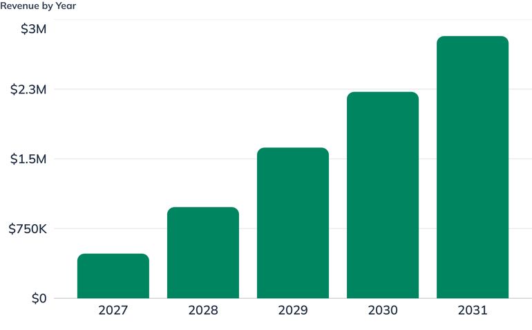
Need real milestones? We recommend using LivePlan as the easiest way to create milestones for your own business plan.Create your own business plan
We forecast four revenue streams, modeled separately rather than blended. This matters more here than in most service businesses: our per-acre rates span from $9 to $185, a twenty-fold range, so a blended average would hide the single assumption that most affects the outcome. Small shifts in mix move revenue further than any change in pricing or utilization.
The four streams
Stream | Driver | Modeled price |
|---|---|---|
Crop Intelligence Programs | Acres enrolled per season | $9 per acre |
Compliance Documentation Packages | Packages delivered | $3,600 per package |
Timber Inventory & Forest Mapping | Acres flown | $28 per acre |
Land Survey & Site Mapping | Acres flown | $185 per acre |
Two of these are blended rates, and we say so rather than leaving the reader to reconcile them against the Solution section:
- Crop Intelligence is modeled at a flat $9 per acre, the season-program rate. In practice a share of each year's acreage is flown as $6-per-acre single-field pilots that convert to programs the following season, and some program acreage carries the $4-per-acre prescription add-on. The two effects run in opposite directions and we model the midpoint rather than forecasting the conversion rate of a business that has not yet sold anything.
- Compliance Documentation is modeled at $3,600 per package, which is the $2,400 base plus $3 per acre on a 400-acre average operation. It also blends first-time filings against lower-priced annual re-verifications. As the mix shifts toward re-verification in later years, package volume grows faster than the blended price would suggest, and we have held the price flat rather than assume otherwise.
Projected revenue
2027 | 2028 | 2029 | 2030 | 2031 | |
|---|---|---|---|---|---|
Crop Intelligence | $153,000 | $270,000 | $396,000 | $504,000 | $594,000 |
Compliance Documentation | $86,400 | $205,200 | $342,000 | $471,600 | $597,600 |
Timber Inventory | $107,800 | $224,000 | $392,000 | $537,600 | $683,200 |
Land Survey & Mapping | $133,200 | $281,200 | $490,250 | $707,070 | $945,350 |
Total | $480,400 | $980,400 | $1,620,250 | $2,220,270 | $2,820,150 |
Growth runs 104 percent in Year 2, then decelerates to 65, 37, and 27 percent — the shape of a business filling capacity in a finite regional market, not a hockey stick.
What the volumes assume
Crop Intelligence grows from 17,000 acres in 2027 to 66,000 acres by 2031. Our six core counties hold roughly 86,800 acres of soybeans and, counting corn and winter wheat in rotation on much of the same ground, on the order of 140,000 row-crop acres; the secondary tier adds roughly 35,000 more. At 66,000 acres we would be flying a little under half the row-crop ground in the core radius — a demanding share that depends on winning the aggregators (ag retailers, co-ops, crop consultants) rather than signing farms one at a time, and one we would expand the radius rather than force. Revenue is concentrated in March through October and is zero in November through February.
Compliance Documentation grows from 24 packages in 2027 to 166 in 2031 — about three a week at full run rate, spread across two filing peaks rather than evenly. This is the most predictable stream in the plan because it is driven by a program calendar and by Virginia's continuing $223 million annual cost-share funding, not by weather or commodity prices. It is also the stream where our US-built aircraft matter most commercially, since these customers are the ones touching federal dollars.
Timber Inventory grows from 3,850 acres to 24,400 acres, concentrated November through March. Against roughly 16 million acres of Virginia forest that is 59 percent family-owned, this is a small share of a large, underserved pool. Its strategic role is counter-seasonal: it fills the exact months when crop imagery has nothing to say.
Land Survey & Site Mapping grows from 720 acres to 5,110 acres and becomes our largest stream by 2031 at 34 percent of revenue. It carries the highest revenue per acre by a wide margin, runs year-round, and is priced against a ground survey alternative costing $15,000 to $30,000 for a 20-acre site. It is also the stream most dependent on partnership with a licensed Virginia surveyor, which is why that relationship is established before the first engagement rather than after.
How the mix shifts
Crop work falls from 32 percent of revenue in 2027 to 21 percent by 2031, while survey and timber rise from a combined 50 percent to 58 percent. That drift is deliberate. Crop intelligence is the wedge that builds relationships and fills the growing season; it is not where the margin per flight hour lives, and it faces direct substitution from satellite imagery at roughly a tenth the cost. Revenue per billable flight hour is the metric we watch to confirm the mix is moving the way it should.
Collections
Our terms are net 30, and agricultural customers — whose own cash arrives at harvest — realistically pay closer to 45 days. We front-load invoicing at 40 to 50 percent on signing across all three service lines specifically to compress that gap. The forecast carries the resulting receivables balance rather than assuming instant collection: year-end accounts receivable runs $33,507 in 2027, $29,993 in 2028, $52,170 in 2029, $94,469 in 2030, and $120,173 in 2031. That growth in receivables is a real claim on working capital, and the cushion described in Use of Funds is sized with it in view.
What could break these numbers
The forecast assumes visual-line-of-sight operations throughout. If the FAA finalizes Part 108 within the horizon, acres per hour rise industry-wide and per-acre pricing compresses — an upside on volume and a risk on rate, and we have not modeled either. Weather is the other exposure: a wet spring in the coastal plain compresses the crop window, and our scheduling buffer assumes reschedules stay under a quarter of booked missions.
Expenses & Costs
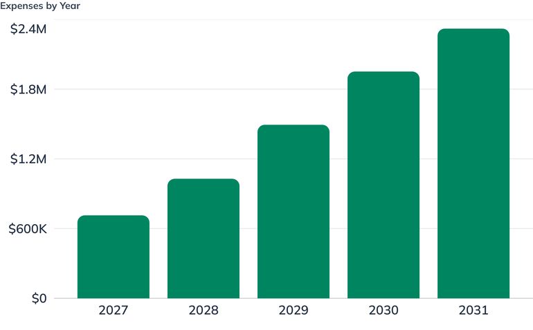
Need real financials? We recommend using LivePlan as the easiest way to create financials for your own business plan.Create your own business plan
Direct costs
Our direct costs are genuinely small — $66,485 in 2027 rising to $395,350 in 2031, or about 14 percent of revenue throughout. That produces a gross margin of roughly 86 percent, which is high but correct for this business type: our field crews are salaried and sit in personnel rather than in cost of goods sold, which is standard for a survey and analytics services firm. Read the gross margin alongside payroll, not on its own.
What is in direct costs is the genuinely per-job spend:
Stream | Direct cost | Basis |
|---|---|---|
Crop Intelligence | $1.15 per acre | Field travel, battery cycles, per-acre data and processing credits |
Compliance Documentation | $520 per package | Certified planner review, plotting and production, site travel |
Timber Inventory | $3.90 per acre | LiDAR processing compute, consulting forester review |
Land Survey & Mapping | $27.00 per acre | Ground control setup, licensed surveyor review and stamp, travel |
The subcontracted licensed-surveyor and certified-planner review costs are the two lines most likely to move. Both are professional services we buy rather than perform, and both are legal requirements rather than optional quality steps, so we treat them as fixed obligations of doing that work rather than as costs to negotiate down.
Personnel
Payroll is our largest cost by a wide margin: $332,000 fully burdened in 2027, growing to roughly $1,268,000 by 2031. As a share of revenue it falls from 69 percent in the launch year to 45 percent by 2031, which is the single clearest signal of the business finding its footing.
Wages are benchmarked to the Richmond metro market specifically — not to a national average, and deliberately not to the Virginia statewide figure, which runs roughly seven to eight percent higher because it is inflated by the Northern Virginia and Washington market. Richmond runs approximately at national par to five percent below for technical and managerial roles and at or slightly above for sales and administrative roles.
Within that market we pay at or above median for scarce skills and at median for roles where local supply is deep:
Role | Starting base | Hired | Positioning |
|---|---|---|---|
Senior UAS Pilot / Field Ops Lead | $72,000 | Mar 2027 | Above median — pilot plus photogrammetry is a scarce combination |
Geospatial Analyst | $70,000 | May 2027 | At/above median (Richmond GIS Analyst I median ≈ $65,400, II ≈ $74,900) |
Office & Admin Coordinator | $28,000 part-time, $50,000 full-time from 2028 | Jan 2027 | At median |
UAS Pilot | $60,000 | Mar 2028 | At median — Part 107 alone is not scarce; 220,000+ certificated pilots nationally |
Account Executive | $62,000 base + commission | Feb 2029 | Base below median, on-target earnings at market on a 60/40 mix |
Agronomy & Client Success Lead | $72,000 | Mar 2029 | At/above median (Richmond agronomist median ≈ $65,500) |
Assembly & Maintenance Technician | $56,000 | Apr 2029 | At median (Richmond electro-mechanical tech ≈ $52,000) |
Operations Manager | $100,000 | Feb 2030 | At/slightly below median (Richmond ≈ $103,800) |
Geospatial Analyst II | $74,000 | Apr 2030 | At/above median |
Third field crew — UAS Pilot III ($64,000) and Field Technician ($54,000) | $118,000 combined at full-year rate | Mar 2031 | Both at median; carried as one two-person line, at $98,333 for the ten months worked in 2031 |
Founders start below market — $68,000 and $74,000 — and step to $130,000 and $135,000 by 2031 as the business supports it.
Employer burden is modeled at 20 percent of base wages, which reconciles to a real Virginia employer: 7.65 percent FICA, 0.6 percent net FUTA, Virginia's 2.5 percent new-employer SUTA rate on an $8,000 wage base, blended workers' compensation of roughly 0.8 percent across field, shop, and office classifications, and employer-paid single-coverage health insurance at approximately $7,900 per employee per year. That last item is flat-dollar, so the effective burden percentage is higher on lower salaries — around 26 percent at $45,000 and 16 percent at $105,000 — and 20 percent is the honest blended figure for our salary mix.
Operating expenses
Operating expenses excluding payroll run $199,500 in 2027 and $458,500 in 2031, plus sales commissions from 2029. The largest lines and why they are sized as they are:
- Facility rent and CAM — $46,000 rising to $64,000. 3,200 sq ft of Henrico flex space at flex-park rates rather than office rates, because we need a shop floor and not a storefront. The step up from 2030 reflects taking adjacent bench space in the same park as the build shop reaches capacity.
- Insurance — $22,000 rising to $54,000. Above entry-level drone insurance benchmarks by design. Hull coverage on self-assembled, non-type-certificated airframes carrying $14,000 sensors is a specialty placement, and survey work for engineering and land-transaction clients requires professional liability and E&O that no aviation liability policy includes.
- Marketing, trade shows, and grower meetings — $34,000 rising to $110,000. Weighted toward exhibit space and travel for four to six annual events rather than digital spend, because purchase decisions in this market are made in person between December and February.
- Vehicle operating costs — $16,000 rising to $58,000. Field-heavy business, day-trip service radius, one vehicle at launch, two from April 2028, and three from March 2031.
- Software and data subscriptions — $14,000 rising to $38,000. Kept deliberately low by anchoring photogrammetry on a perpetual Agisoft license rather than a per-seat subscription. Our software vendors are also our notional competitors, and none of them has an incentive to protect our margin.
- Training, certification, and Green UAS compliance — $18,000 in 2027, elevated in the launch year for the certification application, then $12,000 to $24,000 for recurrent training and the standing quarterly supply chain review.
Profitability
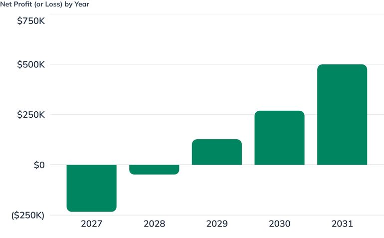
Need real financials? Explore a spreadsheet-free path to generating financial data for your business.Create your own business plan
SkySpecs loses money for two years and then does not. That is the honest shape of a capital-intensive services launch carrying SBA debt from month one, and we would rather state it plainly than engineer a forecast that turns profitable in Year 1 and convinces nobody.
Five-year summary
2027 | 2028 | 2029 | 2030 | 2031 | |
|---|---|---|---|---|---|
Revenue | $480,400 | $980,400 | $1,620,250 | $2,220,270 | $2,820,150 |
Gross margin | $413,915 | $844,020 | $1,394,100 | $1,909,676 | $2,424,800 |
Gross margin % | 86.2% | 86.1% | 86.0% | 86.0% | 86.0% |
Operating expenses | $531,497 | $753,600 | $1,110,708 | $1,480,640 | $1,781,100 |
Operating income (EBITDA) | ($117,582) | $90,420 | $283,392 | $429,036 | $643,700 |
Interest and depreciation | $115,811 | $138,381 | $156,023 | $159,768 | $144,236 |
Net profit | ($233,393) | ($47,961) | $127,369 | $269,268 | $499,464 |
Net margin | (48.6%) | (4.9%) | 7.9% | 12.1% | 17.7% |
Reading the curve
Operating income turns positive in 2028, the second year, at $90,420. This is the number that shows the underlying business works: before financing costs and non-cash depreciation, the company covers its own operations from Year 2 forward.
Net profit turns positive in 2029 at $127,369, and roughly doubles in each of the following two years. The one-year gap between operating profitability and net profitability is entirely explained by two things we chose deliberately: $600,000 of SBA debt taken at launch rather than a thinner facility that would have left no cushion, and $276,000 of equipment bought in month one — three aircraft, a vehicle, a build shop, and a processing lab — which generates $65,000 to $112,000 of annual depreciation against early-year revenue.
The 2027 loss of $233,393 is the plan working as designed, not a warning. The company starts with a $775,000 capital base against roughly $276,000 of assets, deliberately leaving close to $500,000 of working capital to absorb exactly this. A drone services company that reached profitability in its first twelve months would be one that never bought a second aircraft, and an operator with one aircraft down for repair during a three-week timing window loses a season of relationships.
Net margin reaching 17.7 percent by 2031 is consistent with a professional services firm at scale. It is achieved not by raising prices — our rates hold flat across the horizon — but by mix shift toward survey and timber work at $28 to $185 per acre and by payroll falling from 69 percent of revenue to 45 percent as existing staff absorb more volume.
Cash, which is the number that actually matters
2027 | 2028 | 2029 | 2030 | 2031 | |
|---|---|---|---|---|---|
Ending cash | $267,958 | $190,954 | $235,878 | $354,231 | $682,641 |
Accounts receivable | $33,507 | $29,993 | $52,170 | $94,469 | $120,173 |
Cash never goes negative at any point in the forecast. The low point is $186,570 in January 2029 — after two loss years and after buying the second survey aircraft ahead of the leaf-off season, at the bottom of the winter cycle before the crop season resumes. That is roughly 1.7 months of total operating outflow at the 2029 run rate. From that month each year ends higher in cash than the last, within the normal seasonal swings of a business whose crop revenue stops in November, reaching $682,641 by 2031 against the $175,000 the founders originally contributed.
By the end of the forecast roughly $376,000 of the $600,000 SBA facility remains outstanding — about 37 percent retired on a ten-year amortization — and the equipment loan is down to roughly $22,000. Book equity, negative through 2029 as a debt-funded launch necessarily is, turns positive in 2030 at $120,283 and reaches $534,747 by 2031.
Owner distributions of $85,000 per year begin in 2029, sized to cover the personal income tax the founders owe on S-corporation pass-through income — roughly 28 percent of the $896,101 in net profit the business earns across 2029 to 2031. No distributions are taken in the two loss years. They are carried as a real cash outflow rather than assumed away, because a pass-through business that ignores the owners' tax obligation overstates its own retained cash.
Break-even
Our fixed-cost base — payroll, rent, insurance, and the rest of operating expenses — runs approximately $531,000 in 2027 and $754,000 in 2028. At an 86 percent gross margin, break-even revenue is roughly $617,000 in the launch year and $876,000 in the second. We forecast $480,400 and $980,400 respectively, which is why 2027 loses money and 2028 nearly does not.
What we are watching
The forecast is most sensitive to the Land Survey and Timber mix. Those two streams contribute 58 percent of 2031 revenue on a small fraction of the acres flown, so a shortfall there costs several times what an equivalent shortfall in crop acreage would. If survey and timber underperform, the correct response is to slow hiring rather than to chase crop volume at $9 an acre, and that is the decision rule we will actually follow.
Use of Funds
We are raising $775,000 at launch. Roughly a third of it buys assets; the rest is working capital, and we are explicit that the working capital is the more important half.
Startup asset purchases — $276,000
Item | Amount | Useful life |
|---|---|---|
Drone fleet — 2 SS-M multispectral + 1 SS-L survey aircraft with payloads | $118,000 | 4 years |
Spare airframe kit and payload spares | $14,000 | 4 years |
Field crew truck | $38,000 | 5 years |
Build shop equipment and tooling | $32,000 | 7 years |
Geospatial processing workstations and RAID storage | $30,000 | 3 years |
Leasehold improvements (LiPo storage room, ventilation, ESD benches) | $28,000 | 5 years |
Perpetual software licenses (Agisoft Metashape Professional ×2) | $7,000 | 3 years |
Office furniture and equipment | $9,000 | 5 years |
Two of these deserve explanation. The $118,000 fleet buys three aircraft where a leaner plan would buy two, because a single aircraft of each type means a repair during a three-week timing window costs a season of customer relationships. Buying the same two multispectral platforms off the shelf would cost roughly $86,000 at approximately $43,000 each — and that comparison understates the saving, because our $118,000 also includes the SS-L heavy-lift airframe and a LiDAR payload that Equipment & Tools prices at $30,000 to $50,000 on its own. The $28,000 in leasehold improvements is not cosmetic: LiPo-safe storage with fire suppression and dedicated ventilation is a fire code and insurance requirement for a shop assembling and charging aircraft batteries at this volume.
Working capital — approximately $499,000
This is the larger and more important half of the raise. It funds:
- Two years of operating losses. The plan projects a net loss of $233,393 in 2027 and $47,961 in 2028 — the normal shape when a company buys its production capacity in month one and builds a customer base over two selling seasons.
- A seasonal cash cycle that does not match the calendar. Crop revenue is zero in November through February. Timber revenue peaks in exactly those months, which is why the mix exists, but the two do not offset perfectly and the winter trough is real: the forecast's low point is January 2029, at $186,570.
- Receivables. Our terms are net 30 and agricultural customers realistically pay closer to 45 days. The forecast carries that as real receivables — $33,507 at the end of 2027, dipping to $29,993 in 2028 as the December billing mix shifts, then climbing to $52,170, $94,469 and $120,173 through 2031. From 2029 that growth is a real claim on working capital. We front-load invoicing at 40 to 50 percent on signing across all three service lines to hold it down. Assuming otherwise is how a business with a good order book runs out of money in October.
- The second survey aircraft. The SS-L #2 and LiDAR payload bought in November 2028 costs $64,000 against $37,905 of operating cash generated that year. The gap comes out of this cushion, which is precisely what it is for — buying the aircraft ahead of the leaf-off season rather than after it is the difference between capturing the 2028–29 timber peak and missing it.
- The launch-year cost of compliance. Green UAS certification, legal and accounting formation costs, and the initial supply chain documentation work all land before meaningful revenue does.
The cushion is sized so that the forecast's lowest cash point is roughly 1.7 months of operating outflow rather than a number that technically stays above zero. We would rather carry slightly more debt service than run a business that survives only if nothing goes wrong.
Later capital — $78,000 in 2028
A separate equipment term loan funds SS-M aircraft #3 with a thermal payload ($42,000) in March 2028 and a second field operations vehicle ($36,000) in April, matched to the second pilot hire. That is the last borrowing in the plan. The SS-L #2 in November 2028 is funded from the working capital cushion, as described above, and every capital purchase from 2029 forward — the processing lab expansion in June 2029, the four-year fleet refresh in March 2030, and the sixth aircraft and third vehicle in March 2031 — is funded from operating cash flow, which by then runs $211,152, $343,307 and $584,006 against asset spending of $22,000, $75,000 and $95,000.
What we are deliberately not spending on
We are not buying a spray drone or entering application work: different insurance, different chemical handling exposure, different economics. We are not building a fourth aircraft in the launch year; capacity beyond three airframes is added when utilization proves it is needed, not in anticipation. We are not taking a Richmond storefront or office-grade space. And we are not funding a sales hire until February 2029, because the founders sell this offer better than anyone we could hire before the motion is proven and documented enough to teach.
Sources of Funds
Launch capital — $775,000
Source | Amount | Share | Terms |
|---|---|---|---|
Founder equity contribution | $175,000 | 22.6% | Cash, no repayment obligation |
SBA 7(a) term loan | $600,000 | 77.4% | 9.5% fixed, 120 monthly payments (10 years) |
Total at launch | $775,000 |
Founder equity of $175,000 is contributed in cash by Nathan Ordway and Priya Raghunathan at formation, in proportion to their shareholdings. At 22.6 percent of total capitalization it comfortably exceeds the roughly 10 percent equity injection SBA lenders typically require of a startup borrower, which is deliberate: a thin injection on a from-scratch business invites a declined application, and the founders' own money in the deal is the first thing a credit committee looks for.
The SBA 7(a) term loan of $600,000 is structured over ten years at 9.5 percent fixed, generating debt service of approximately $7,760 per month and roughly $51,000 of interest expense in the first year, against roughly $34,500 of principal repaid. We chose the ten-year term over a shorter amortization specifically to protect early cash flow — a five-year term on the same principal would add roughly $4,800 per month of principal repayment during the two years when the company can least afford it, and would push the forecast's cash trough below a defensible level.
The facility is personally guaranteed by both founders, as is standard at this size, and key person life insurance is carried on both with the company as beneficiary. We are pursuing the loan through a Virginia community bank or credit union with an agricultural lending desk rather than the lowest-quoted lender. Our receivables cycle follows harvest, and a lender who has never financed a business paid at harvest will misread our autumn cash flow every single year.
Growth capital — $78,000 in 2028
Source | Amount | Timing | Terms |
|---|---|---|---|
Equipment term loan | $78,000 | March 2028 | 8.5% fixed, 60 monthly payments (5 years) |
An equipment-secured facility funds SS-M aircraft #3 with its thermal payload ($42,000) and a second field operations vehicle ($36,000), timed to the second pilot hire. Equipment lending prices below the general 7(a) rate because the collateral is specific and identifiable, and the shorter five-year term matches the assets' service life rather than outrunning it.
Everything after that is self-funded
That equipment facility is the last borrowing in the plan. The second SS-L survey aircraft in November 2028 is funded from the launch working capital cushion, and from 2029 forward every capital purchase — the processing lab expansion, the four-year fleet and sensor refresh, and the sixth aircraft and third vehicle — comes out of operating cash flow. Total capital raised across the five-year horizon is $853,000, all of it in the first fifteen months, with no outside equity at any point.
Why no outside investment
We are not raising equity beyond the founders', and we do not intend to. This is a regional services business with a finite addressable market — on the order of 140,000 row-crop acres and a defined set of forest and land customers inside a day's drive of Richmond. It can reach $2.8 million in revenue and nearly 18 percent net margin on debt and retained earnings, and it should. Outside equity would require a growth trajectory this market cannot honestly support, and would pressure us toward the spray-application and multi-state expansion moves we have specifically chosen not to make.
Debt service and repayment
2027 | 2028 | 2029 | 2030 | 2031 | |
|---|---|---|---|---|---|
Operating income (EBITDA) | ($117,582) | $90,420 | $283,392 | $429,036 | $643,700 |
Total debt outstanding, year end | $565,502 | $592,594 | $533,367 | $468,412 | $397,176 |
Ending cash | $267,958 | $190,954 | $235,878 | $354,231 | $682,641 |
Interest coverage is negative in the launch year — which is why the working capital cushion described in Use of Funds exists — turns positive at roughly 1.6× in 2028, and reaches approximately 5× in 2029 and more than 15× by 2031. At the end of the forecast, roughly $376,000 of the $600,000 SBA facility remains outstanding, about 37 percent retired on its ten-year schedule, with the equipment loan down to roughly $22,000. Ending cash of $682,641 stands against a founder equity contribution of $175,000, and book equity has turned positive at $534,747.
Projected Statements
Frequently Asked Questions
A drone services business plan should cover the specific services you fly and how they are scoped and priced, the customer segments that can actually buy at those rates, your position against substitutes like satellite imagery and traditional ground survey, the FAA and supply-chain regulations you operate under, your fleet and processing capacity, and financial projections with startup costs, funding sources, and a realistic path to profitability. SkySpecs's plan pairs its three service lines — Crop Intelligence, Compliance Documentation, and Land & Timber — with a county-by-county acreage analysis of its 60-mile Richmond service radius, a Part 107 and domestic-content compliance section, a $775,000 funding plan, and five-year projections.
SkySpecs launches on $775,000 — $175,000 of founder equity from Nathan Ordway and Priya Raghunathan plus a $600,000 SBA 7(a) term loan at 9.5% fixed over a 120-month term. Only $276,000 of that buys assets, including three aircraft with payloads at $118,000, a field crew truck, build shop tooling, and geospatial processing workstations; the remaining $499,000 is working capital sized to absorb two years of losses and a seasonal cycle in which crop revenue is zero from November through February. The founder injection is 22.6% of total capitalization, roughly double the 10% equity SBA lenders typically require of a startup borrower.
Commercial drone work in the US requires an FAA Remote Pilot Certificate with a small UAS rating under 14 CFR Part 107, and Remote ID broadcast compliance has been mandatory since March 16, 2024, with civil penalties reaching $27,500 per violation. Because SkySpecs assembles its own airframes, they are not Standard Remote ID aircraft by default, so compliant broadcast capability is carried as a required line in every build specification. The plan also works through the December 2025 FCC Covered List action on foreign-produced aircraft and critical components, and the Buy American domestic-content thresholds — 65% through 2028, rising to 75% from 2029 — that its provenance claims rest on.
SkySpecs charges per acre across three lines that share one aircraft fleet and one processing pipeline: Crop Intelligence at $9 per acre per season with a $1,800 minimum per operation, Compliance Documentation at $2,400 per plan plus $3 per acre, and Land & Timber at $28 per acre for LiDAR timber inventory and $185 per acre for engineering-grade topographic and site mapping. Gross margin runs about 86% across the forecast, because the cost of delivery is largely flight time and processing rather than materials. Revenue grows from $480,400 in 2027 to $2,820,150 by 2031, with the mix shifting toward the higher-per-acre survey and timber work.
SkySpecs's plan projects operating income turning positive in 2028, its second year, at $90,420, with net profit following in 2029 at $127,369 — after a $233,393 loss in 2027 and a $47,961 loss in 2028. The one-year gap between operating and net profitability comes from carrying $600,000 of SBA debt from month one and depreciating $276,000 of equipment bought before meaningful revenue existed. Net margin reaches 17.7% by 2031, achieved through mix shift and payroll falling from 69% to 45% of revenue rather than through price increases.
SkySpecs treats satellite imagery as its top of funnel rather than its competitor, which is a deliberate response to arithmetic it cannot win head-on: Planet Labs delivers 3.5-meter imagery at roughly $0.85 per acre per year against $6 to $9 per acre for a single drone flight. The plan runs free Sentinel-2 and low-cost Planet coverage across enrolled acreage to triage where something is changing, then dispatches aircraft to the anomalies at 100 to 200 times the resolution. Drone imagery wins only where resolution is the binding constraint — stand counts, gap and skip detection, drainage micro-topography, and any measurement that has to survive a compliance review — and on cloud cover, which routinely blanks the weekly satellite pass in the humid Mid-Atlantic.
SkySpecs sells to three segments inside a 60-mile radius of Richmond: row-crop operations above 400 acres, along with the ag retailers, cooperatives, and independent crop consultants who can put the company across ten operations with one relationship; Virginia producers pursuing Resource Management Plans, nutrient management plans, or Agricultural Cost-Share funding; and non-industrial private forest owners holding 50 to 500 acres, plus consulting foresters, land trusts, and rural real estate brokerages. The plan is explicit that Virginia's 187-acre average farm is too small to clear a viable job at ag rates, so the buyer is the upper tail — roughly 300 to 400 operations in the primary radius clear the 400-acre threshold. The conservation segment self-selects for SkySpecs, because participants touching federal dollars have a procurement reason to avoid providers flying covered foreign hardware.
Seasonality is the structural reason SkySpecs runs three service lines instead of one. Crop work fills the growing season and builds the customer relationship, compliance work recurs annually against Department of Conservation and Recreation program deadlines, and timber and survey work flies best in leaf-off conditions from November through March — exactly the months when crop imagery has nothing to say, and the work that carries the highest revenue per acre by a wide margin. The plan is candid that the two halves do not offset perfectly, and funds the remaining winter trough from working capital: the forecast's low cash point is $186,570 in January 2029.

Business Plan Outline
Start your plan